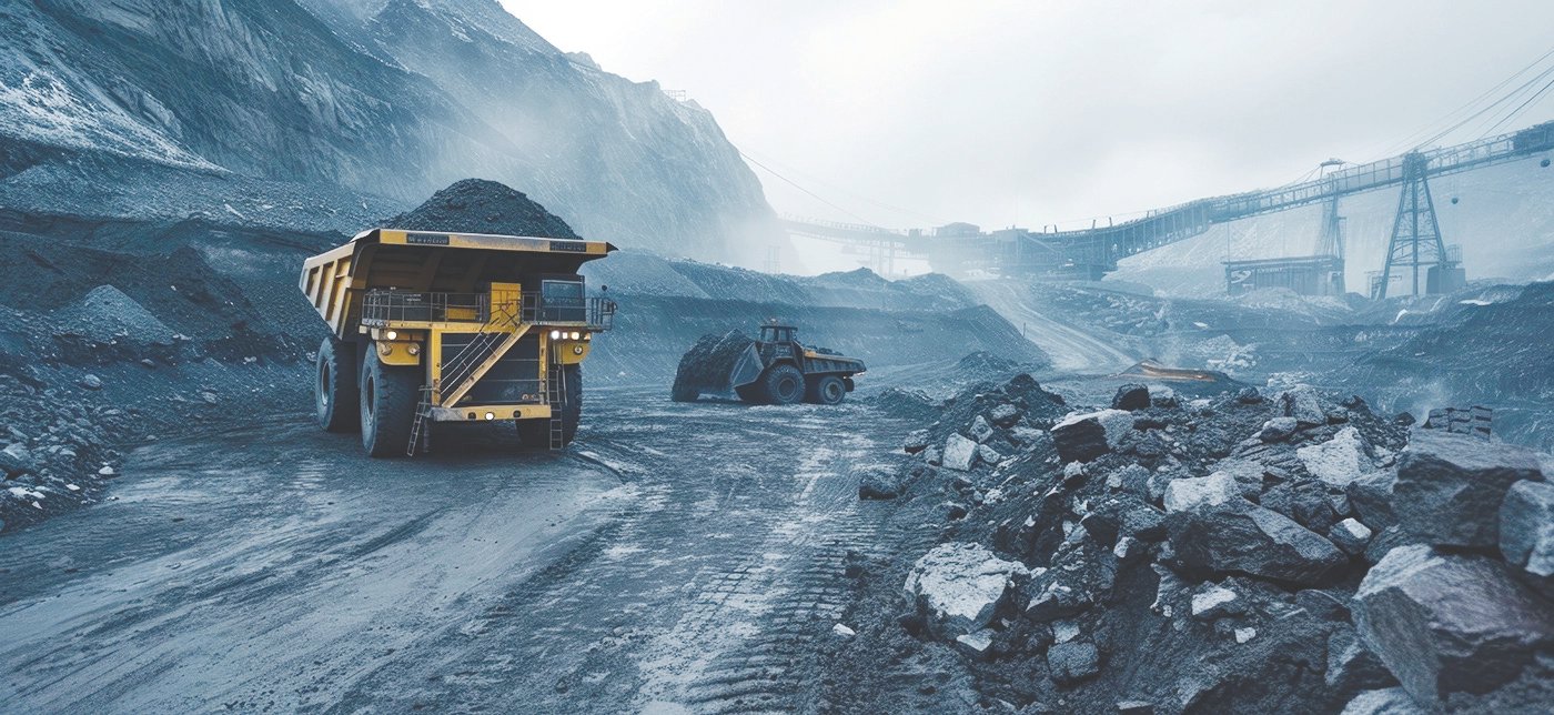
The Khalashpir coal mine stands as a notable example of prolonged delay despite its significant strategic potential for Bangladesh’s energy security. Although a formal development application was submitted in 2006 by the Hoasaf Group in partnership with a Chinese consortium, the project has remained stalled for nearly two decades, primarily due to administrative indecision. Authorities have repeatedly cited the absence of a finalized coal policy as the key obstacle. However, this position has been criticized by experts, who argue that development activities should not be delayed while a specific policy is being formulated.
The Khalashpir Coal Basin, located in Pirganj Upazila of Rangpur District, is a significant Permian Gondwana coal deposit and was first identified in 1959 by Stanvac, USA, during the drilling of an exploratory oil well. The well was drilled up to a depth of 2875m and found to be a dry hole. Later exploration carried out by the Geological Survey of Bangladesh (GSB) between 1989 and 1990 confirmed the presence of high-quality bituminous coal at depths ranging from 284 to 480 meters. This discovery established Khalashpir as one of the country’s most promising coal deposits.
Exploration History
Exploration of the Khalashpir Coalfield was significantly advanced by the Geological Survey of Bangladesh (GSB) during 1989–1990, when four boreholes (GDH-45, 46, 47, and 48) were drilled. Three of these wells (GDH-45, 46, and 47) intersected coal seams of potentially mineable thickness at depths ranging from approximately 257 to 483 meters, while GDH-48 encountered only limited, non-commercial coal, indicating the western boundary of the deposit. The basin is a northwest–southeast elongated, fault-bounded structure covering about 25 square kilometers.
Subsequent investigations identified eight distinct coal zones at depths between 257 and 483 meters. Coal is classified as medium-volatile, low-sulfur bituminous, with certain seams showing strong metallurgical potential due to favorable maceral composition.
In 2004, Hosaf International Ltd, in partnership with a Chinese consortium, undertook further exploration, with additional drilling carried out by Geotech-India, bringing the total number of boreholes to 19. These studies confirmed the presence of high-grade coal with good calorific value and low sulfur content, along with associated minerals such as limestone and glass sand. A mining lease application submitted in 2006 by the consortium proposed underground mining with an annual production target of around 3 million tonnes.
In 2009, International Mining Consultants Limited (IMCL) of the UK conducted a comprehensive technical and economic review at the request of Petrobangla. The report emphasized the need for further exploration in accordance with international standards.
Coal Zones and Distribution
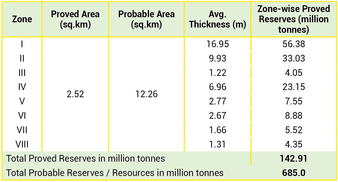
The coal-bearing sequence of the Khalashpir Coalfield is located within the upper part of the Gondwana Group, with an average cumulative thickness of about 44 meters across eight identified coal zones. Zone I, occurring at depths of approximately 257 to 332 meters, is the most prominent and averages about 16.95 meters in thickness. Notably, it includes a three-meter section with high vitrinite content (around 80 percent), indicating strong metallurgical potential. Zone II also comprises multiple seams and features an upper section of about seven meters dominated by inertinite, making it suitable for blending in coke production. The remaining zones (III–VIII) show variations in thickness and lateral continuity. Among them, Zone III is the thinnest, with an average thickness of around 1.22 meters, while other zones occur as thinner and less continuous seams. Overall, the distribution and quality of these coal zones underscore the technical and economic significance of the deposit.
The Khalashpir Coalfield is characterized by a fault-bounded trough (graben) developed within the crystalline basement, aligned along a northwest–southeast axis. The basin exhibits significant structural deformation, including a major fault on the north-northeast side near borehole GDH-46, with an estimated displacement (throw) of about 150 meters.
Structural Geology
The structural geology of the Khalashpir basin reveals a composite fault-bounded trough, or graben, formed within the crystalline basement. The basin is aligned along a northwest–southeast elongated axis and marked by significant faulting, including a prominent fault on the north-northeast side near drill hole GDH-46, with a calculated throw of approximately 150 meters. Gravity anomaly maps further indicate that the basin comprises several smaller sub-basins, evidenced by three prominent gravity highs located at Pirganj, Bhendabari, and Bhadhuria.
Proximate Analysis
Comprehensive laboratory analyses conducted by the GSB and the United States Geological Survey provide detailed insight into the quality of coal from the Khalashpir Coalfield. Proximate analysis indicates an average moisture content of about 1.3%, ash content of 21.8%, volatile matter of 22.9%, and fixed carbon of approximately 54.1%, with higher concentrations observed in Zones I and II. The sulfur content is relatively low, averaging around 0.77%.
Coal demonstrates a strong calorific value, averaging about 11,264 BTU per pound and reaching up to 13,880 BTU per pound in Zone I, highlighting its suitability for high-energy applications. Overall, these characteristics classify Khalashpir coal as medium- to high-volatile bituminous coal with favorable chemical properties for both power generation and industrial use.
Coal Reserve / Resource Estimation
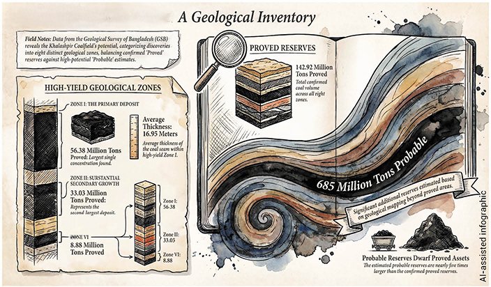
Resource estimation for the Khalashpir Coalfield is based on a geological certainty framework that distinguishes between proved reserves confirmed by detailed drilling and probable reserves inferred from broader geophysical data. According to the GSB, the estimates are derived from eight identified coal zones. Proven reserves are concentrated within a core area of approximately 2.52 square kilometers, centered around boreholes GDH-45, GDH-46, and GDH-47, and are estimated at 142.9 million tonnes. Zone I holds the largest share (approximately 56.4 million tonnes), followed by Zone II (around 33.0 million tonnes). Beyond this core area, total resources are estimated at approximately 685 million tonnes across a wider zone, indicating substantial additional potential.
The coal reserve estimation by the GSB is furnished below:
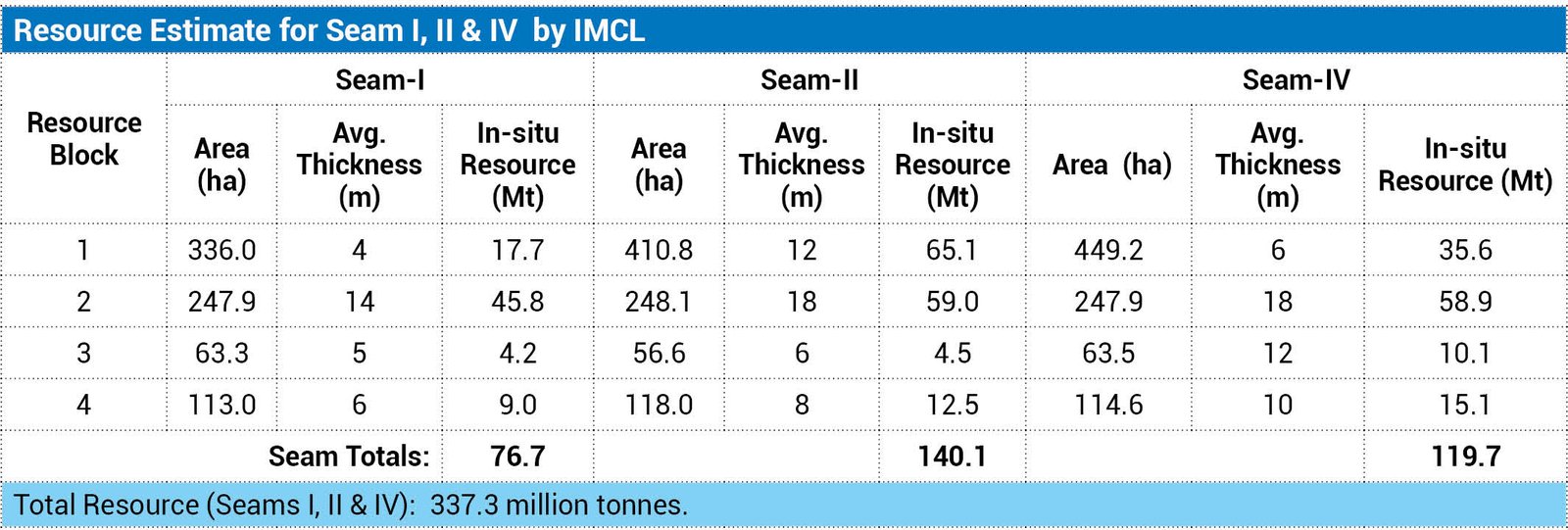
In 2009, an assessment by International Mining Consulting Limited (IMCL) further estimated that the in-situ resource of the three principal seams (I, II, and IV) alone is about 337 million tonnes, underscoring the substantial scale of the deposit.
|
Resource Estimate for Seam I, II & IV by IMCL
|
||||||||||||||||||||||
|
|
||||||||||||||||||||||
Economic Viability
Analytical studies confirm that coal mining from the Khalashpir Coalfield is suitable for thermal applications, particularly for electricity generation. In addition, certain zones exhibit high vitrinite and inertinite content, indicating potential metallurgical value for use in steel production. Reviews, including the 2009 study by IMCL, emphasize the need for detailed techno-economic feasibility assessments to determine its commercial viability. Exploiting Khalashpir could support a 300–500 MW coal-fired power plant, enhance national energy security, create thousands of jobs, and stimulate socio-economic development in Pirganj and neighboring areas, making it a strategic asset for both energy and regional growth.
The prolonged delay in developing the Khalashpir coalfield is particularly significant in the context of Bangladesh’s steadily growing energy demand. The Power System Master Plan (PSMP) 2010, prepared by JICA, set an ambitious target of 40,000 MW of power generation capacity by 2030, with around 20,000 MW expected to come from coal. However, this strategy was subsequently revised in the Gas Sector Master Plan 2017 and later in the Integrated Energy and Power Sector Master Plan 2023, reflecting a shift toward greater reliance on imported LNG, coal, liquid fuels, LPG, and cross-border electricity. At present, domestic coal production remains limited to the Barapukuria mine, which produces less than 1 million tonnes annually. This creates a substantial supply gap that is largely being met through imports.
Environmental, Social, and Safety Hazards
The development of the Khalashpir Coal Mine entails significant environmental, social, and occupational risks that require careful management:
· Surface Subsidence: Underground longwall mining is expected to cause the land above to sink. Extraction of a 5-meter-thick seam could create depressions up to 3.5 meters, leading to waterlogging and loss of rice-cultivated land. Comprehensive socio-economic mitigation will be necessary, including land acquisition, farmer compensation, and potentially the construction of resettlement villages.
· Underground Temperatures: Geothermal conditions at mining depths reach approximately 40°C. Heat generated by machinery will require robust ventilation and cooling systems to ensure safe working conditions.
· Gas and Fire Risks: The mine is classified as “gassy” due to methane emissions, necessitating strict explosion prevention measures and potential methane drainage systems. Additionally, the coal is prone to spontaneous combustion, posing a fire risk in mine waste areas and surface stockpiles.
· Water Management: Large volumes of water will be produced, requiring treatment to remove suspended solids and prevent acid mine drainage before safe discharge into rivers or use for irrigation.
Proper planning, strict safety protocols, and environmental safeguards will be essential to mitigate these hazards while enabling sustainable coal extraction.
Feasibility and Financial Modeling
The Hosaf Group feasibility study, carried out in 2006, is considered incomplete, lacking a detailed implementation schedule, phased production plans, roadway development, and realistic capital and operating cost assessments. Financial assumptions, such as a low coal sale price ($50/tonne) and high discount rates, were unrealistic.
Environmental, Social, and Safety Hazards
The development of the Khalashpir project carries significant environmental and occupational risks that require careful mitigation:
Surface Subsidence
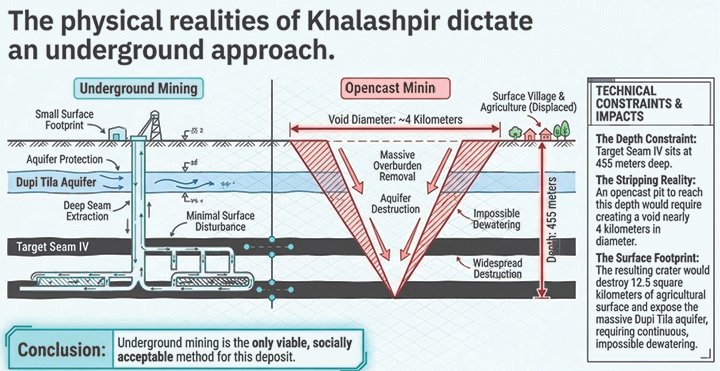
Surface subsidence will have a severe and direct negative impact on local agriculture, which is the primary source of income for the region and currently produces surplus yields of rice. Because the local topography is extremely flat, varying in elevation by less than 1.0 meter, the existing rice cultivation is highly sensitive to changes in water levels and regional drainage. Even a modest surface subsidence of just 300 to 500 millimeters will cause severe waterlogging. As underground longwall mining progresses, surface depressions are expected to reach up to 3.5 meters deep. This drastic alteration of the landscape will effectively preclude rice production and make it impossible to cultivate other crops during the monsoon season. Consequently, the destruction of this arable land will result in a direct loss of livelihood for the majority of the local population who depend wholly on farming.
To mitigate these effects and extend the period the land can be farmed, experts suggest temporarily restoring local drainage through localized pumping or building up land levels using pre-stripped waste material. In the long term, reviewers recommend that the mining consortium purchase the affected land upfront and invest in upgrading surrounding, lower-yield agricultural areas to offset the lost crop production and help retain farming jobs in the region.
Underground Temperatures: Due to the region's geothermal gradient, the original rock temperature at the target mining depths is around 40°C. High-powered machinery will add to this heat, requiring extensive ventilation and cooling systems to maintain a safe working environment.
Gas and Fire Risks: The mine is classified as "gassy" due to methane emissions from the coal beds, requiring strict explosion prevention measures and potentially methane drainage systems. Furthermore, the coal has a high risk of spontaneous combustion, meaning it can catch fire if exposed to low-velocity air currents in the mine's waste areas or surface stockpiles.
Water Management: The mine will discharge enormous amounts of water (potentially tens of thousands of cubic meters daily), which must be routed through physical and chemical treatment plants to remove suspended solids and prevent acid mine drainage before being discharged into local rivers or used for irrigation.
Recommendations and Observations by IMCL
In 2009, IMCL reviewed the consortium’s feasibility study and recommended several key actions to ensure that the Khalashpir coal mine development is both commercially viable and safe:
· To conduct further exploratory drilling using a reputable contractor with modern equipment following international JORC (Joint Ore Reserves Committee) standards, including downhole geophysical logging such as Natural Gamma Ray, Gamma-Gamma, Density, Calliper, and Temperature.
· To perform 3D numerical groundwater flow modeling to manage water-related risks.
· To complete a comprehensive Environmental Impact Assessment (EIA) covering construction, operation, and closure phases.
· To undertake a detailed market study to evaluate the commercial value of both cooking and thermal coal outputs.
These recommendations provide a framework for planning safe, economically viable, and environmentally responsible mining operations.
Sample Analysis
All core samples must be logged and prepared per JORC principles, supervised by senior JORC-accredited geologists. Analyses should be performed by at least two accredited international laboratories, following standard procedures. Coal quality proximate analyses must be carried out on all exploratory cores to support computer-based resource modeling.
Geological Criteria for Mine Design
Consider lessons from Barapukuria Coal Mine, Bangladesh’s first underground coal mine. Despite differences in sedimentology and structure, both sites share a near-surface Dupi Tila aquifer, which poses significant water inflow risks. Care must be taken to prevent delays caused by uncontrolled water ingress. Mine design should integrate deposit geology, faulting, coal seam characteristics, expected production, underground conditions, and surface layout/accessibility to ensure safe and efficient operations.
Mine Design and Engineering
For the Khalashpir Coalfield, underground mining is strongly preferred over opencast methods due to the depth and large volumes of the overlying Dupi Tila aquifer. The recommended method is highly mechanized top coal caving longwall mining, with extraction sequences guided by progressive strata control modeling to limit subsidence beneath the aquifer to 10 mm per metre.
Vertical shaft construction should use the Artificial Ground Freezing (AGF) technique to stabilize the water-saturated Dupi Tila formation, transitioning to standard grouting in deeper, more stable rock units. The underground layout should optimize pit placement for gravity-assisted drainage and level access, while computer-modeled ventilation systems are essential to manage heat, methane emissions, and spontaneous combustion risks.
Underground Extraction Methods
Coal extraction at the Khalashpir Coalfield is recommended using two primary underground methods, depending on seam geometry:
· Longwall Mining: For thicker seams, highly mechanized longwall mining is advised. While the original feasibility study proposed hydraulic stowing to support the roof, this method has been criticized as costly and often ineffective. Instead, top coal caving longwall faces are recommended for efficient extraction of thick seams.
· Pillar and Stall: For flatter seams, especially in the southern parts of the deposit, pillar and stall mining with remote-controlled continuous miners is preferred. This method preserves roof-supporting coal pillars and provides operational flexibility, though it achieves a lower extraction ratio.
Government Decision
On 2 April, 2026, the Government of Bangladesh informed Parliament that a final decision on coal extraction from Khalashpir would be taken only after completion of a comprehensive feasibility study. In response to a written question from Md. Nurul Amin, the Power, Energy, and Mineral Resources Minister highlighted the coalfield’s historical exploration, significant resource potential, and the need for careful, evidence-based evaluation before any development.
Coal Development Plan
The present government has outlined a phased Coal Development Plan and Barapukuria Coal Mine Expansion Plan to strengthen national energy security. Within the first 180 days, a national seminar will be organized on coal production and utilization, aimed at framing policy directives and adopting integrated development plans for the five discovered coalfields. Building on these directives, during 2026-27, techno-economic feasibility studies will be approved and initiated in line with the national plan. During the same period, feasibility studies will be completed, mining development projects will be formulated, and project activities will commence. Subsequently, during 2028-30, experimental coal extraction will begin, providing critical insights into operational viability and informing the scaling up of coal-based energy initiatives.
The phased approach is clear and aligns with best practices in coal project development. However, for effective implementation, the plan should ensure early finalization of coal policy, include environmental and social safeguards, define mining methods and infrastructure needs, and incorporate realistic timelines and financing mechanisms.
Domestic Coal Production and Imports
Domestic coal production in Bangladesh remains limited, with the Barapukuria Coal Mine producing less than 1 million tonnes annually, reflecting constrained capacity. In contrast, coal imports by the private sector have grown steadily, exceeding 12.7 Mt in FY 2023–24. This trend highlights the country’s increasing reliance on imported coal to meet rising energy demand, while domestic production contributes only a marginal share of total supply.
Commercial production at Barapukuria began in September 2005 with a designed annual capacity of 1 million tonnes. At present, daily output ranges between 2,500 and 3,000 tonnes, with approximately 1.1 million tonnes in FY 2024–25, primarily supplying the 525 MW Barapukuria coal-fired power plant.
With domestic natural gas production expected to decline, coal is emerging as a viable alternative to strengthen energy security. Currently, coal accounts for about 35% of total electricity generation; however, domestic coal contributes less than 3%, underscoring the significant gap between local production and national demand. The coal import scenario from FY 2019–20 to FY 2024–25 is as follows:
Way Forward
The Khalashpir Coalfield represents a significant yet underutilized primary energy resource in Bangladesh. While legitimate environmental and social concerns must be addressed with due diligence, the prolonged delay in decision-making highlights a broader challenge within the country’s energy sector. Amid rising energy demand and increasing dependence on imported fuels, continued inaction on Khalashpir raises a critical question: how long can such a valuable resource remain untapped?
An immediate review and update of the existing techno-economic feasibility study is therefore essential. In line with recommendations by International Mining Consultants Limited, the government should take prompt and concrete steps to undertake a comprehensive and up-to-date feasibility assessment without further delay.
Mortuza Ahmad Faruque: Energy Expert and Former Managing Director, BAPEX
Download Special Article As PDF/userfiles/EP_24_02_SA_Chisty.pdf