

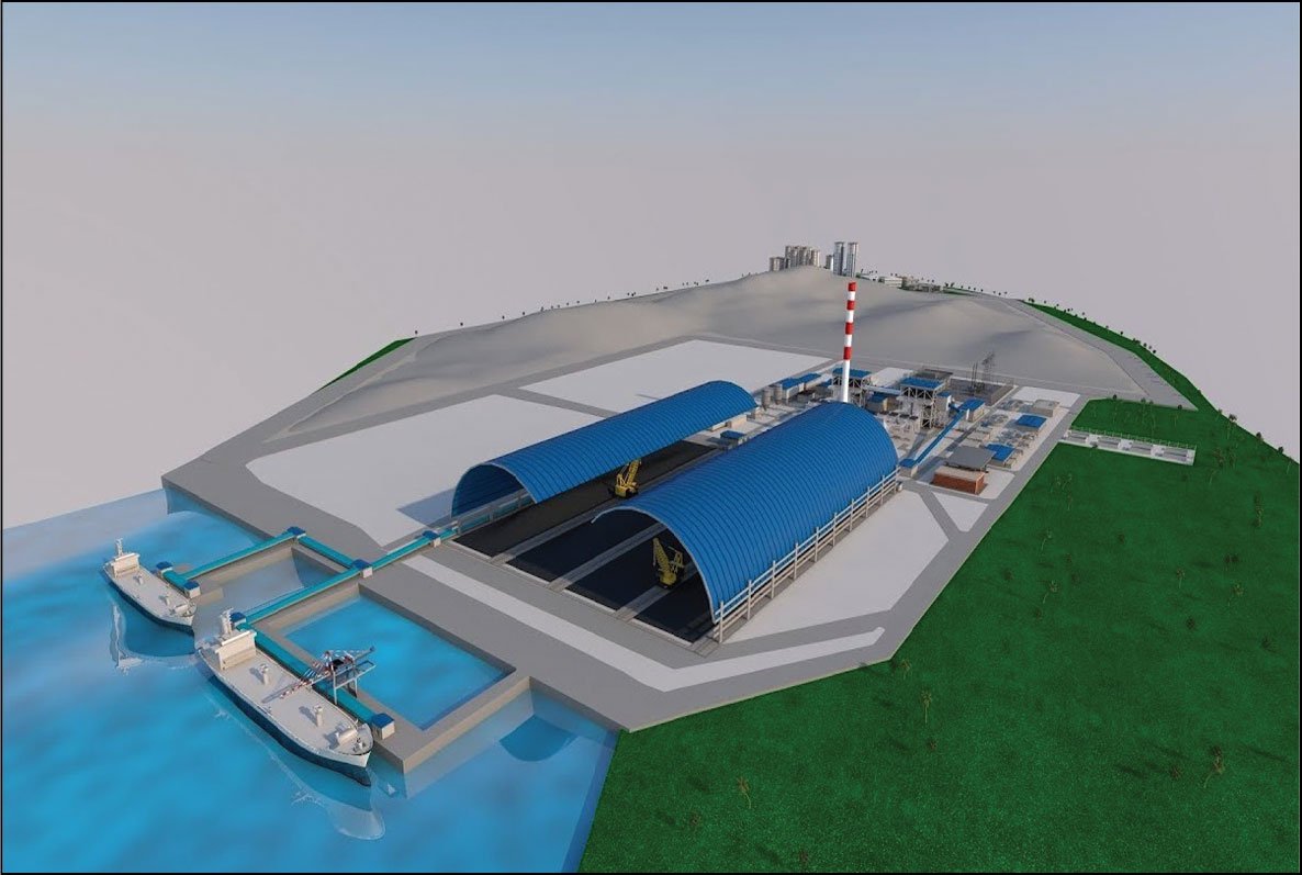
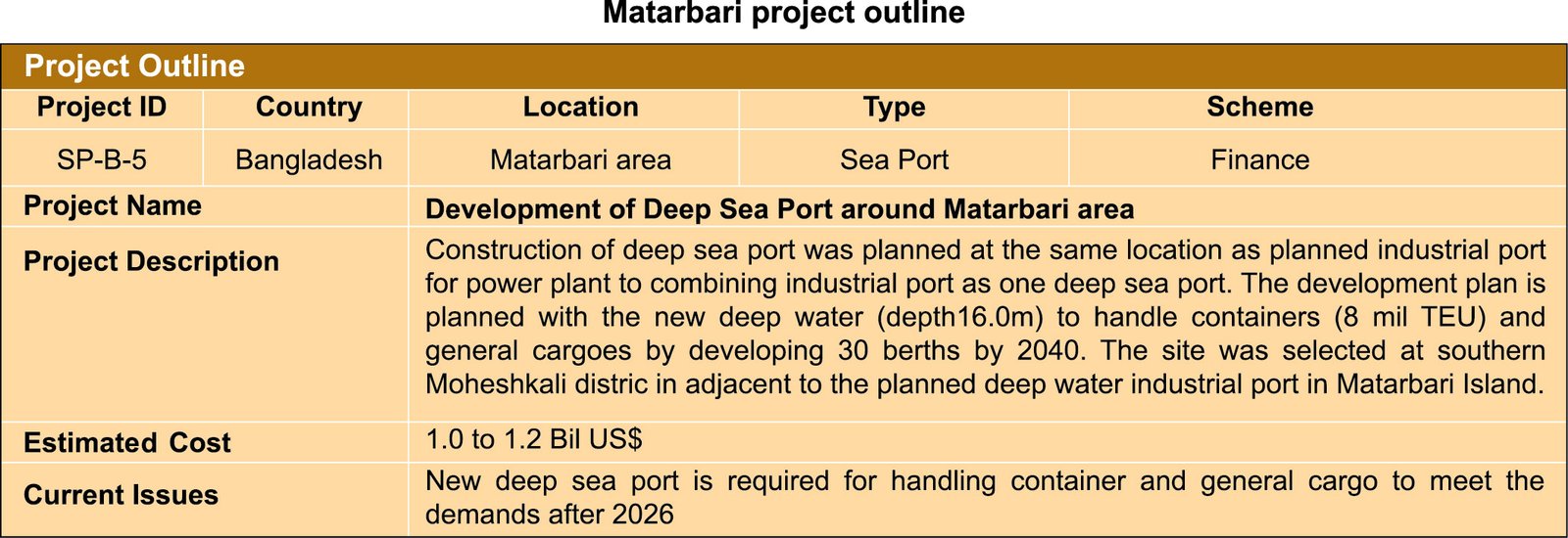
Matarbari Port is an under-construction deep seaport in Maheshbhai Upazila of Cox's Bazar District, Bangladesh. In the first stage, one 300-meter-long multipurpose terminal and one 460-meter-long container terminal will be constructed by 2026. The ports navigation channel will be 350-meter long with a draught of 16 meter where the biggest deep-sea container ships, with the capacity of 8,000 twenty-foot equivalent units (TEUs) will be able to dock. The deep-water terminals will be quickly and safely accessible from the open sea. As a result, ships can be unloaded and reloaded quickly and sent on their way to next destination.
Matarbari New Deep-water Port Development
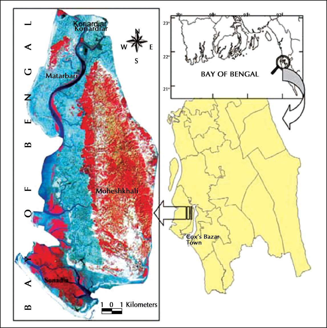
The deep-sea industrial port is planned for receiving imported coal for the thermal power plant in the Matabari area. Soil conditions in the region are very soft and weak, worse than expected when compared with the soil survey results of the Fundamentals of surveying. The power plant and deep-water port foundations needed extensive soil improvement.
Unfortunately, there are no sand sources for land reclamation from the seabed sand, mountain sand in the vicinity around the project area, there is no place where procurement of the sandy soil of the land reclamation can be secured. The breakwater construction is required in order to protect the approach channel from high waves during monsoons. Some parts of the project area are nominated as environment protected areas. Some rare birds use this as a breeding area and these will be protected.
The Matarbari seaport is limited in space and the pressure on the marine environment, resulting from an expansion of existing uses and increase in new ones, has been devastating in many places. Essentially, the increased activity has led to two important types of conflict in the marine environment.
First, not all uses are compatible with one another and are competing for ocean space or have adverse effects on each other (user vs. user conflicts). Numerous examples exist of conflicts between ocean users globally and locally.
Spatial use conflicts also occur within one particular use and refer, for example, to the use of different gear types for fisheries in certain areas, or the competition over use of space between commercial and recreational fisheries. Another conflict occurs between offshore wind farms if they are built in trawling fisheries.
Second, not all uses are compatible with the needs of a healthy and sustainable environment and cause conflicts between users and the environment (user vs. environment conflicts). Too often, sea uses are insensitive biological and ecological areas with little consideration of their impact. Many scientific studies document the degradation of the world’s oceans, the decline of marine ecosystems, and the collapse of important fisheries, increasingly impairing the ocean’s ability to produce the goods and services essential for life on Earth. Resilience is the capacity of a social-ecological system to absorb or withstand perturbations and other stressors such that the system remains within the same regime, essentially maintaining its structure.
During the past 10 years, the evolution of MSP and ocean zoning has become a crucial step in making ecosystem-based sea use management a reality. Despite academic discussions and the fact that some countries have already started implementation, the scope of MSP has not been clearly defined. MSP is an essential step to achieve ecosystem-based sea use management. Terms such as integrated coastal management, management of large marine ecosystems (LME), marine spatial management, and ocean zoning are all used inconsistently. This is one of the reasons its importance is not more seriously reflected at the levels of policy and decision-making in most countries. MSP is an essential step to achieve ecosystem-based sea use management. All three sectors of society—government, civil society, and business—are necessary for effective ecosystem-based management (EBM) and bring together the ideas and concepts of ecosystem-based marine spatial management. Matarbari seaport area needs to illustrate that MSP should be an adoption of marine and coastal interests rather than an extension of existing planning on the land.
A key characteristic of ecosystem-based management is that it is place-based or area-based, which is a marked departure from existing approaches that usually focus on a single species, sector, activity or concern. Where sectoral management implies that each sector regulates particular activities or projects taking place at a particular location (or site) within a certain area, EBM implies that, after an area has been defined, sustainable development and use will be established for all activities in the whole area. MSP and ocean zoning, especially in areas where conflicts among users and the environment are already clear, have become a crucial step in managing ecosystem-based sea use.
As a comprehensive approach to managing uses of the sea, marine spatial planning (MSP) is a public process of analyzing and allocating the spatial and temporal distribution of human activities in marine areas. All this, in order to achieve ecological, economic and social objectives that are usually specified through a political process.
It plays a key role in supporting the development of sectors that have a high potential for sustainable jobs and economic growth linked with maritime activities—also known as ‘blue growth’ and ‘blue economy’—while highlighting the need to consider climate change effects on the durability of sectorial approaches within existing blue economy strategies.
Countries have public and private institutions with the potential to contribute to this management approach for blue economy; still, institutional differences confuse powers and functions, making integrated management a difficult task.
Encouraging the creation of adequate coastal and ocean governance frameworks, ensures principles of an ecosystem-based approach and puts them into practice. MSP enables the development of tools to assess the cumulative impacts and pressures of human activities in the sea through the improvement of knowledge, data and information on the land-sea interactions.
In turn, this ensures that the use of marine resources is ecologically sustainable and applying measures to reach good environmental status of the coastal and marine environment. It is possible to implement this approach regionally, nationally and locally through an inclusive and transparent intergovernmental process on sustainable development goals that is opened to all stakeholders.
Matarbari Sustainable Blue Economy
The challenge is to integrate the concept into the strategic planning of a nation considering the unprecedented problems the marine ecosystems are facing. Still, in a sustainable manner and in combination with ecosystem-based management processes and tools, the blue economy becomes the most appropriate context for public and private interactions.
In the Matarbari seaport, six traditional and emerging sectors are considered the main pillars of the blue economy due to their high potential for the future. These include marine living resources (fisheries and aquaculture, farming of fish, shellfish and marine plants), marine extraction of non-living resources (gravel, sand, zinc, cobalt, copper), maritime transport, port activities, shipbuilding and repair and coastal tourism. Other emerging sectors, such as renewable energies (wind, waves, tides, biofuel), biotechnology (medicines, cosmetics, industrial enzymes) belong to industries appearing on coastal regions.
The Japan International Cooperation Agency (JICA) provides technical cooperation and other forms of aid promoting economic and social development. On 21st March 2019, JICA presented a plan for Moheshkhali—Matarbari integrated infrastructure development proposal at the Prime Minister’s office. Prime Minister Sheikh Hasina said that the largest coal-fired power plant of the country, coal jetty and an LNG terminal are being built in Matarbari.
The industries and factories will be built around the proposed power and energy hub in Matarbari. She is eager to build a modern world-class Deep Seaport at Matarbari. JICA said in its presentation that the deep seaport they are offering to build at Matarbari will be 18.7 meters deep and the first stage to complete by 2024.
The economic zone in that area will be beside the LNG terminal which will be constructed to meet energy needs. With the establishment of the Dhaka-Chittagong National Highway N-1 and the Railway track, direct communication between Chittagong and Cox's Bazar will be established with Matarbari.
Marine spatial plans and the blue economy are initiatives led by public authorities to further harness the potential of ocean, sea and coastal areas for jobs, value and sustainability and as a response to the global changes which affect national interests.
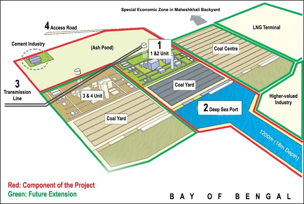
Figure 3: JICA suggests building a long-term power and energy hub around Matarbari deep seaport region by the end of 2041
Hydrographic surveying is one of the important parts of port operations as vessels are using less keel clearance for maximum loads. Safe navigation needs regular surveys, delivered on time and to specified accuracies. Hydrology, water modelling, climate change aeromodelling and GIS data are activities of all asset management departments of the Matarbari port. Maps need to be established to directly affect decision making in vessel traffic management. Because the hydrographic production system is so closely linked and integrated with the port’s enterprise GIS, the hydrographic data are readily utilized by all areas of the port. This innovative approach to hydrography truly allows the data to be used for more than charts and creates potential for hydrographic data outside of traditional uses. GIS will be an asset management system and provides the framework for the hydrographic production at the port. The hydrographic system consists of three primary components: The Bathymetry Information System (BIS), the Nautical Information System (NIS) and the Maritime Chart Server (MCS).
Sea-Level Rise in Ports: A Wider Focus on Impacts
In this article, we assess the impacts of climate change on seaports for different global warming level scenarios. The results refer to the potential risks associated with two scenarios, represented by sea-level rise projections that have been estimated considering mean sea level, tides, waves and storm surges. Two-thirds of Bangladesh is less than five meters above sea level. 28% of the population of Bangladesh lives on the coast, where the primary driver of displacement is tidal flooding caused by sea level rise. By 2050, with a projected 50 cm rise in sea level, Bangladesh may lose approximately 11% of its land, affecting an estimated 15 million people living in its low-lying coastal region.
The process of “salinization” has been exacerbated by rising sea levels. Coastal drinking water supplies have been contaminated with salt, leaving the 33 million people who rely on such resources vulnerable to health problems such as pre-eclampsia during pregnancy, acute respiratory infections and skin diseases.
Agriculture, the mainstay of the Bangladesh economy, is also badly affected and crops damaged by rising salinity are doubly at risk from the resulting soil degradation. Many regions have already suffered large yield losses and significant price reductions as a result. It has been estimated that by 2050, one in every seven people in Bangladesh will be displaced by climate change. Up to 18 million people may have to move because of sea level rise alone. The eastern coastal region of Bangladesh, which has a 377 km-long coastline, is highly vulnerable to multi-hazardous events, such as tropical cyclones, coastal floods, coastal erosion and salinity intrusion. The vulnerability of this coastal region is likely to increase under the future climate change context.
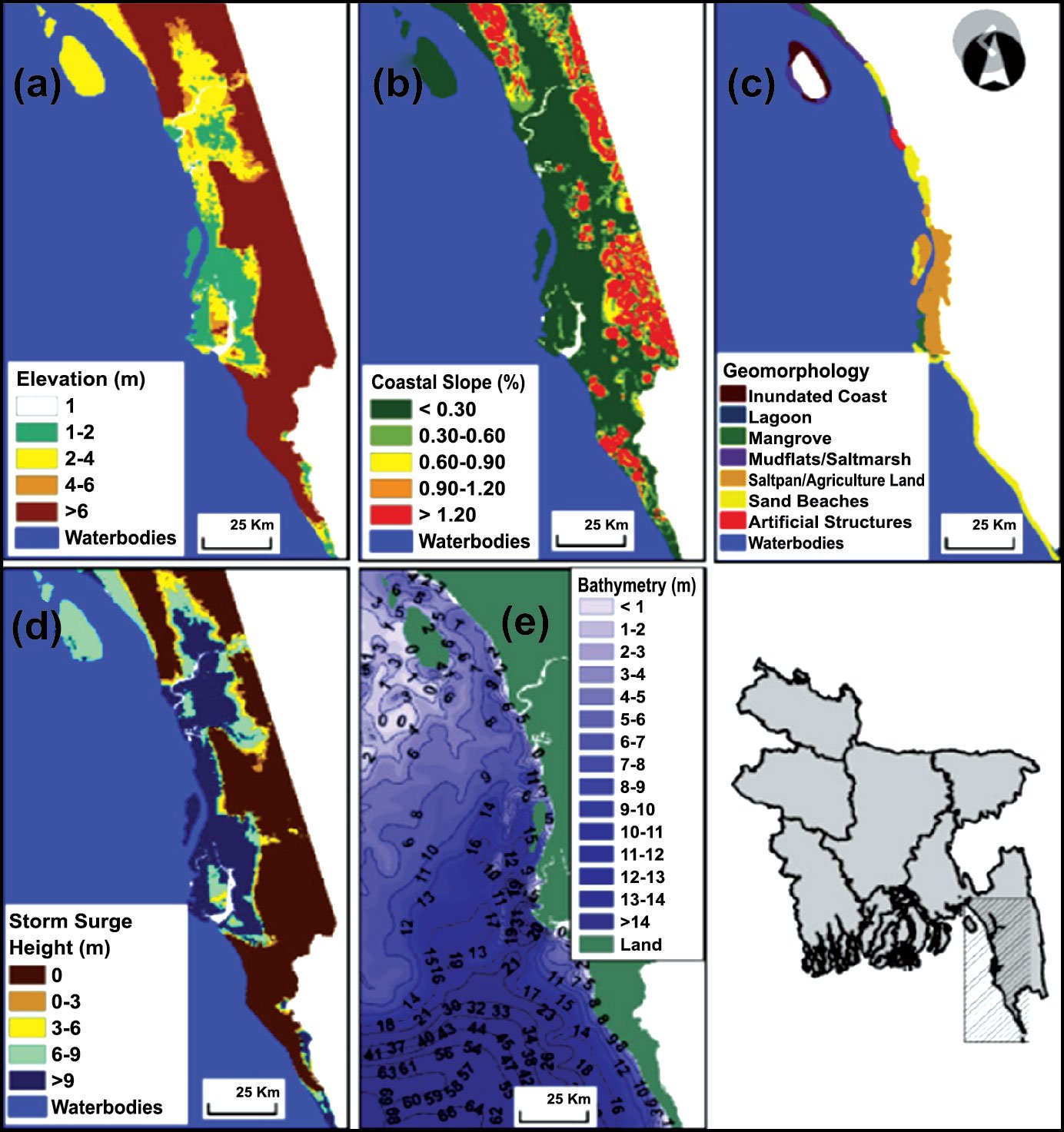
Figure 4: Low elevations, gentle slopes, high storm surge impacts, sandy coastlines, bathymetry and geomorphology. Source: https://www.sciencedirect.com/science/article/abs/pii/S0964569119301486
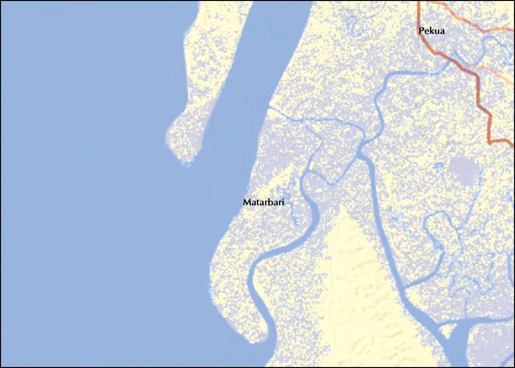
Figure 5: Matarbari 4-meter sea level rise map
Maritime spatial planning (MSP) will become an increasingly important issue for the maritime sector in the coming years. Maritime professionals need to interact with other users of the waterway space, both maritime and coastal, and take part in international, regional, national and local MSP debates. This is to ensure that the needs of the maritime sector are considered. Full consideration and that the sector understands the needs of other users and marine resources. The Nautical Institute, together with the World Ocean Council, has put together this operational guide to the risks and benefits related to the maritime sector that should be considered during the MSP process. This guide seeks to outline just a few of the many engagement opportunities and issues to consider. It should be noted that this guide only summarizes some of the main issues, but still provides reference to other industry documents for further technical and procedural details. This guide was produced specifically to help maritime professionals participate in MSP developments. For the sake of brevity, the guide assumes a certain level of maritime competence and has not attempted to clarify several maritime terms and definitions. If this guide is to be used by non-mariners (and we hope it is) it may be useful to seek further explanations of some of the problems from those familiar with maritime operations. The comprehensive MSP is usually long-term, general in nature and policy-oriented and is implemented through more detailed zoning maps, zoning regulations and a permit system. MSP processes seek to better manage ocean spaces by balancing ecological, social and economic objectives using public and participatory processes. To meet this challenge, MSP approaches and tools have evolved globally, from local to national scales. The current arrangements for the management of Bangladesh's marine resources are not adequate for sustainable management. Marine spatial planning (MSP) can be a tool for achieving sustainable management of marine resources. The Government of Bangladesh is planning the development of MSPs for the sustainable management of marine resources in the Bay of Bengal. However, a clear understanding of the current and required legal and institutional arrangements for MSP development in Bangladesh is essential for the sustainable management of marine resources.
Dr. Nasrin Sultana, Snb.sdml@gmail.com https://www.geospatialaus.com/about/
References:
https://profilebd.blogspot.com/2019/03/matarbari-deep-seaport-and-power-hub.html
https://openjicareport.jica.go.jp/pdf/12251989.pdf
https://www.sciencedirect.com/science/article/abs/pii/S0964569119301486
https://www.nautinst.org/uploads/assets/uploaded/299f934f-ee69-492e-8ada51abf26e8b19.pdf